


 ABC News(NEW YORK) — The winter storm that dumped 10 to 20 inches of snow on parts of Missouri, Iowa and Illinois from Friday into Saturday is hitting the East Coast on Sunday. The storm will bring heavy snow and ice from North Carolina to Maryland.
With at least 10.9 inches of snow in St. Louis through early Sunday, this is the biggest snowstorm the city has seen in five years. Montgomery City, Missouri, had already seen 20 inches of snow, while Dulles International Airport was just seeing the beginning of the snow by 5 a.m. with 3.8 inches.
There are two parts of the storm system affecting the Midwest and East Coast on Sunday morning. A coastal low is beginning to take shape off the Carolina coast line and will strengthen as it begins to head out to sea.
Heavy snow bands are currently hitting parts of the Washington, D.C., metro area, as well as down through parts of Roanoke and Charlottesville, Virginia. Snowfall rates in these areas could range from 1 to 2 inches per hour through the morning.
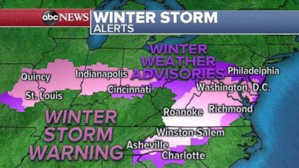
Additionally, there is mixed precipitation in western North Carolina on Sunday morning. Ice could rapidly accumulate in the morning hours in that region, especially from Winston-Salem, North Carolina and west.
There are still winter weather alerts from Missouri to southern New Jersey Sunday morning. The winter weather alerts will begin to expire from west to east as the day goes on.
Much of the snow should be consolidated to the Mid-Atlantic, especially Virginia and Maryland. Some light snow is also expected to reach parts of Pennsylvania and New Jersey, with the best chances for notable accumulation of snow in the southern parts of those states.
The High Resolution Rapid Refresh model shows heavy snow bands lasting through much of the day in Washington, D.C., and northern Virginia, where some of the highest snowfall totals will come.
There is the possibility for over 6 inches of snow in northern Virginia and parts of Washington, with some areas likely to approach 1 foot of snow. Additionally, over half an inch of ice is possible in parts of North Carolina and southern Virginia.
As the storm pulls out to sea it will usher in another blast of cold air with wind chills in the teens and single digits for much of the Northeast on Monday morning.
Half a foot of rain likely in Southern California
On the West Coast, a storm caused some relatively minor mud and debris flows in Southern California on Saturday. However, several more Pacific storms are on the way this week and the concern for flash flooding, mudslides and debris flows will increase in the coming days.
Another storm will arrive in Southern California on Monday, and another one will sneak in right behind by Tuesday.
Several rounds of rain will likely dump 4 to 6 inches of rain on parts of Southern California this week.
Heavy mountain snow is also expected for the entire Sierra Nevada range, and parts of the mountains outside Los Angeles. A winter storm watch has been posted for the Southern California mountains with locally over 1 foot of snow and 60 mph wind gusts possible.
Copyright © 2019, ABC Radio. All rights reserved.