


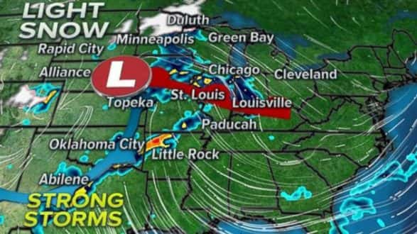
 ABC(NEW YORK) — A new storm is moving through the central United States on Saturday morning, bringing heavy snow to parts of the Northern Plains and Midwest. Heavy snow is currently falling throughout parts of southern Minnesota, northern Iowa and western Illinois. On the warmer side of the storm, locally heavy rain has developed across Nebraska, Missouri and southern Illinois.
As much as 8 inches of new snow has been reported in Minot, North Dakota, and 4 inches of snow has already been reported in Charles City, Iowa.
Winter weather advisories and winter storm warnings currently stretch from the Dakotas into the mountains of Virginia and North Carolina.
The storm will quickly slide to the south and east Saturday with locally moderate snow moving toward central Illinois, Indiana, southern Ohio and into the central Appalachians. Peoria, Illinois; Indianapolis, and Cincinnati will all see snow, and low visibility is expected in this region with travel delays possible.
The highest snowfall accumulations will be in central and northern Iowa, as well as western Illinois, where over 6 inches of snow is likely. In the Ohio Valley and central Appalachians, snow will fall mainly during the day. The relatively high sun angle in late March will limit snowfall accumulations from Illinois to Virginia. Locally 3 to 5 inches of snow is expected from Indianapolis to Roanoke, Virginia, with most accumulation expected on grassy and elevated surfaces.
The storm clears the East Coast by late Saturday.
Seasonable temperatures for Northeast
High pressure will develop early next week across the East Coast, which will finally stop the parade of nor’easters and winter-like weather that has been affecting the Northeast over the last couple of weeks. By midweek, many cities in the Northeast will see their warmest temperatures since early March.
New York and Boston could make a run at its warmest weather since March 1, when it was 60 degrees. New York is currently running 2.8 degrees below its monthly average temperature in March. Boston is currently running around 1.3 degrees below its monthly March average temperature. The last time Philadelphia was above 55 degrees was on March 1, with a high of 58 degrees. March’s average temperature is nearly 4 degrees below average.
Unfortunately, as we head toward April, there remains uncertainty about whether the seasonable temperatures will stick around in this region.
New storm developing
A new storm system will develop late Sunday in the high plains and move to the east on Monday. High pressure along the East Coast will slow the weather pattern down.
As a result, slow-moving storms will develop along a cold front moving across the Southern Plains and Mississippi River Valley during the week.
The thunderstorms could turn severe on Monday across Oklahoma and Texas with damaging winds, large hail and possible tornadoes from Tulsa to San Angelo. A slight risk has been issued for that region already.
The slow-moving storms will slide off to the Mississippi River Valley and Gulf states by Tuesday and Thursday. The potential for widespread heavy rain and possible flash flooding by midweek is increasing, with many locations across the region forecast to receive at least 3 to 4 inches of rainfall.
Copyright © 2018, ABC Radio. All rights reserved