


 ABC News(NEW YORK) — The first storm of the holiday weekend moved through the upper Midwest on Saturday, bringing as much as a foot of snow in northern Minnesota. Now another storm is developing in the Central Plains on Sunday and rapidly moving to the east — with snow likely from Nebraska to Ohio on Easter Sunday.
Snow will reach Missouri and Illinois by the early evening hours, and then move into Indiana and Ohio by Sunday night. Occasional heavy bursts of snow are likely, which will reduce visibility. Although the snow will have some difficulty sticking to roadways, slick and treacherous spots will develop in the region Sunday evening, and travel will be impacted.
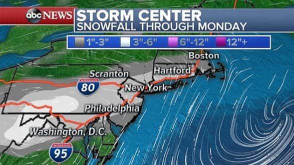
Early on Monday, a new low pressure will develop off the Delmarva peninsula and quickly move to the north and east. As a result, a band of heavy snow will develop along the I-95 corridor from Washington, D.C., to Boston. By Monday morning, heavy snow will be falling in many of the major I-95 cities. The snow will once again have difficulty sticking to the roadways, but it is looking like it will come hard enough to accumulate to some degree. Snowfall rates of 1 inch per hour are possible in the region.
The Monday-morning commute will likely be treacherous from Washington, D.C., to Hartford, including New York and Philadelphia. The storm clears out by early afternoon.
Winter weather advisories have been posted from eastern Wyoming to central Illinois. Winter weather advisories have also been posted for the Philadelphia and New York metro areas for Monday morning.
Snowfall totals on Sunday will be 1 to 3 inches along I-70 from Kansas City to Indianapolis, with isolated higher totals. Totals of 2 to 4 inches are possible near Philadelphia and New York, with the highest totals outside the major cities and on grassy surfaces.
Feeling like winter
Behind the system, winter-like air is moving in. Wind chills on Easter morning are in the single digits and teens across much of the Midwest. On Monday, some of the cold air moves east, with wind chills in the 20s across much of the I-95 corridor.
Some spots, such as Philadelphia and Washington, D.C., saw temperatures in the 70s last Thursday and Friday. It will feel nearly 40 degrees colder on Monday morning.
New storm to develop
Another storm is expected to develop in the central U.S. late Monday. The first impact will be another swath of potentially heavy snow across the Dakotas and into the upper Midwest by Tuesday. There is the potential for more than 6 inches of snow across parts of Minnesota, Wisconsin and northern Michigan — with locally higher totals by Wednesday morning.
On the warmer side of the storm, heavy rain and some thunderstorms are expected to move into the Mississippi and Ohio River valleys by Tuesday. Further south, strong to severe thunderstorms will develop from eastern Texas to western Tennessee by Tuesday. Damaging winds and large hail look to be the primary threat.
Copyright © 2018, ABC Radio. All rights reserved.