


 ABC News(NEW YORK) — Strong thunderstorms are moving into the Northeast Thursday morning before some of the hottest temperatures this year, beginning Friday.
Some of Thursday’s thunderstorms could produce very heavy rainfall and flash flooding in spots. More thunderstorms will develop in the region during the day on Thursday, with an isolated severe thunderstorm possible and localized flash flooding. The greatest risk for flash flooding will be through parts of New England.
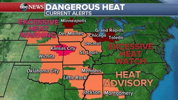
Behind the system, a major ridge of high pressure is developing in the central U.S. Summer heat is building across much of the central U.S. on Thursday, with triple-digit heat index temperatures likely from Alabama to Nebraska. Heat advisories have been issued for this region, and excessive heat warnings and watches now have been issued for some major metro areas such as Kansas City, Chicago and Minneapolis.
On Thursday afternoon, the heat index could reach as high as 110 degrees in Kansas City. A couple of record highs will be possible in parts of Colorado, Nebraska and Wyoming, where the actual air temperature will head into the lower 100s.
The heat expands Friday, with a large part of the eastern U.S. seeing heat index values approaching or exceeding 100 degrees. Heat index values in Iowa, Illinois and Missouri are expected to reach 110, with isolated areas nearing a heat index of 115 degrees. Parts of the Northeast, including New York City, will see their first day of a developing heat wave in the Northeast with temperatures near 90.
Then the heat really cranks up over the weekend with temperatures heading into the upper 90s across the entire Northeast. Heat index values over the weekend could reach over 100 degrees in some areas. New York City is looking at a high of 97 degrees on Sunday, while Albany, New York, and Washington, D.C, will both near 100 degrees.
A prolonged period of 90-degree or higher heat is likely, so it will be classified as a heat wave in the Northeast. The warmest temperature New York City has seen so far this year is 92 on May 3.
Progress made with Pawnee fire
The Pawnee fire has burned 13,700 acres in Lake County, California, but firefighters made gains on the fire on Wednesday, with containment up to 30 percent. Some evacuation orders have finally been lifted due to good progress containing the fire.
The Spring fire in Colorado is now 1,200 acres and has prompted a few evacuations in Costilla County.
The Sardinas Canyon fire in New Mexico remains in a fairly rural part of the state, but smoke is blowing into several areas of New Mexico, including Taos.
There will be another day of very warm temperatures across much of the West on Thursday, with triple digits likely from the Southern California deserts to Colorado and New Mexico. Temperatures in parts of interior California will be on the rise over the next few days, with temperatures back into the 100s from Friday through Sunday.
Gusty winds, low relative humidity and high heat will bring the next round of high fire conditions across parts of the West from Northern California to Colorado on Thursday and Friday.
Copyright © 2018, ABC Radio. All rights reserved.