


 ABC News(NEW YORK) — Snow, ice and rain wreaked havoc throughout the Midwest and Northeast on Wednesday and Thursday, but it’s a return to winter chill that will affect those regions over the weekend.
More than a foot of snow fell from Colorado to Michigan over the past several days, while spots in Missouri saw over half an inch of ice and over 6 inches of rain fell in Nashville, Tennessee.
On Friday morning, two storms are moving across the country, one through the Northeast and a new one entering the West Coast.
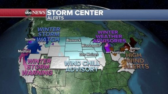
Snow, wind and cold alerts stretch from the West Coast to the East Coast on Friday.
The storm that brought all the snow, ice, flooding and tornadoes to the middle of the country is moving through the Northeast Friday morning with just rain and some freezing rain in New England.
The storm will be gone later Friday morning into the afternoon.
Behind the storm, a significant arctic chill is moving in, with wind chills 20 to 40 degrees below zero on Friday morning in the Northern Plains.
This arctic air mass moves east by Friday evening, with wind chills in the single digits in the Northeast and below zero in the Upper Midwest on Saturday morning.
West Coast storm
Moving on to the West Coast, Winter Storm Warnings and Watches have been posted from Washington to California with heavy snow forecast even in Seattle.
Seattle may get hit with unusually heavy snow — up to a half a foot in the city and up to a foot in the suburbs. Even Portland, Oregon, could get a few inches of snow.
The Sierra Nevada Mountains in California could get up to 4 feet of snow this weekend. Rain moves into San Francisco and Los Angeles during the day Friday, into Friday night, and continues into the weekend as a new storm moves into the area. Some flooding and mudslides are possible after heavy precipitation earlier in the week.
Copyright © 2019, ABC Radio. All rights reserved.