


 ABC News(NEW YORK) — A new winter storm racing across the country will bring snow from the Plains to the Midwest during the day before bringing significant snow to the Northeast and severe weather to the South late Sunday. Dangerously cold air, with wind chills as low as minus 40, will move into parts of the central U.S. behind the storm.
Boston Public Schools announced that they will be closed on Monday due to the snow forecast.
At least 3 inches of snow was reported in Denver Sunday morning from this storm, with 4 to 8 inches of snow reported in the foothills west of Interstate 25 in the Denver and Colorado Springs metro areas. Locally, 3 to 5 inches of snow is being reported in western Kansas.
The snow shield was moving across parts of Kansas, Oklahoma and Nebraska early Sunday with difficult travel expected on Interstate 70, Interstate 35 and Interstate 80.
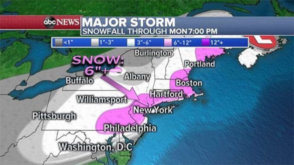
At least 110 million Americans were under a winter weather alert on Sunday morning, including winter storm warnings, winter storm watches, winter weather advisories, wind chill warnings and wind chill advisories. Philadelphia, New York City and Boston are all included among the winter storm warnings. Also, nearly 24 million Americans are at risk for severe weather in the South on Sunday.
Boston Public Schools announced that they will be closed on Monday due to the snow forecast.
The major storm continued to race across the country Sunday. Snow moved parts of the Midwest during the morning, while heavy rain moving into the Mississippi River Valley could fall at rates of 1 to 2 inches per hour. Flash flooding is possible because some parts of this region are very saturated from heavy rain the last two weeks.
Most of the eastern U.S. will be impacted by this major storm by late Sunday afternoon with significant severe weather in the South and snow moving into the Northeast, including Maryland, New Jersey and Pennsylvania.
On Sunday afternoon a line of intense storms will form along the cold front and become intense during the late afternoon and early evening hours. There is an enhanced risk for severe weather across parts of Alabama and Georgia with strong tornadoes possible, along with damaging winds and large hail.
The storm will intensify as it tracks Northeast late Sunday into early Monday. It remains to be seen how close the rain/snow line comes to the major Interstate 95 cities as the latest guidance shows the rain/snow line will be right on or near I-95.
There will be a wide swath of 3 to 6 inches of snow across the Northeast from Pennsylvania to Maine. However, there will also be an area from New Jersey to Massachusetts that will likely exceed 6 inches of snow. This region’s snow totals will ultimately be determined by where the rain/snow line sets up. New York City and Boston are projected to get 6 to 8 inches of snow, while Hartford, Connecticut, will see 4 to 6 inches.
The storm will begin to pull away from the Northeast early Monday. The storm will be moving rather fast, and the heaviest snow will be late Sunday night before the storm quickly moves off to the north and east.
Brutal cold will move in behind the storm. Wind chills are as low as minus 30 and minus 40 in the Northern Plains and parts of Upper Midwest early Sunday. This air will move east over the next 48 hours. By Tuesday morning, single-digit wind chills will arrive in the Northeast.
Copyright © 2019, ABC Radio. All rights reserved.