


 ABC News(NEW YORK) — A powerful storm developed on Wednesday bringing a historic and crippling blizzard from the Rockies into the Plains, severe weather to the South and powerful winds throughout the entire central U.S.
The storm is responsible for closing interstates, stranding drivers, blowing trucks over and damaging trains. As the storm was intensifying Wednesday, a couple of preliminary record low pressures were recorded in Colorado and Kansas. It is fair to say this is one of the strongest storms to hit the High Plains in decades.
The storm is bottoming out in pressure and will begin to decrease in intensity on Thursday as it moves to the north and east. However, through Thursday the storm will still bring dangerous blizzard conditions to the Plains, the next round of severe weather to the Midwest and South and strong damaging winds and possible flooding to the entire central U.S. At this time, there are no significant impacts expected on the East Coast.
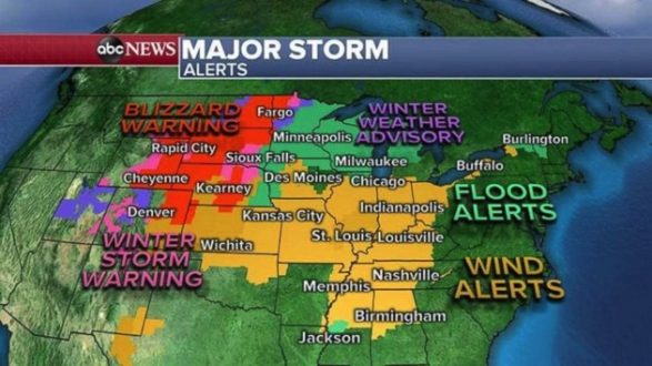
A large part of the country from the Rockies to the Midwest to the Ohio River Valley are seeing alerts because of this storm, including blizzard warnings, flood alerts and wind alerts. The morning radar is showing the snow shield over the Central and Northern Plains. Meanwhile, on the warmer side of the storm, thunderstorms and damaging winds are firing across parts of Texas, Arkansas and Louisiana.
Additionally, strong storms have been hitting parts of Mississippi and Tennessee on Thursday morning.
The precipitation is decreasing in intensity, but the threat from the wind, snow melt, ice jams and new severe weather exists in the South and Midwest.
Winds over 50 mph are possible across much of the central U.S. on Thursday. Those winds will maximize across the Dakotas, but strong winds will reach Indianapolis, Chicago and St. Louis. There could be downed trees, power outages and some property damage across much of the central U.S. due to these powerful winds.
Additionally, there is a new severe component to this storm in the southern U.S. A line of storms moving through eastern Texas, northwest Louisiana and southern Arkansas could bring some damaging wind gusts through the morning hours.
There is an enhanced risk for severe weather on Thursday from Mississippi to Michigan, including Nashville, Louisville and Indianapolis. In the enhanced risk region there could be a few tornadoes. There could also be damaging winds and large hail across this region.
Trailing thunderstorms could cause flash flooding.
East Coast avoids most impacts
The storm will move into southern Canada and race off north of the United States. The storm will continue to decrease in intensity as well.
There could be some locally strong wind gusts across parts of the Great Lakes into Thursday night, however, calmer and quieter weather should overtake much of the Northeast by Friday with only a couple of showers. Gusty winds should remained confined to the Great Lakes region.
Much of the Northeast will see a nice spring preview on Friday with temperatures warming into the 60s. There is a chance as the cold front nears the region it could spark a few isolated gusty thunderstorms Friday late afternoon. No significant severe weather or substantial wind is expected.
Copyright © 2019, ABC Radio. All rights reserved.