


 ABC News(NEW YORK) — Hurricane Dorian continued to amble its way up along Florida’s east coast early Wednesday morning, lashing the Sunshine State with heavy rain and gusty winds.
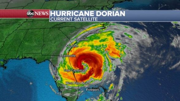
Dorian has weakened to a Category 2 hurricane, with sustained winds of 105 mph, but forecasters warn the slow-moving storm still poses a threat to the southeastern United States and could possibly make landfall as it inches closer to the Carolinas.
The eye of the storm has remained offshore of Florida but is starting to collapse, causing the outer rain bands to extend even further away from the center and strike coastal communities. Tropical storm force winds are reaching a whopping 175 miles away from the center. Wind gusts near 70 mph were reported Wednesday morning in New Smyrna Beach, Florida, according to ABC News meteorologists.
Dorian slammed into the Bahamas on Sunday afternoon as a Category 5, the strongest Atlantic hurricane landfall on record.
The storm hovered over the archipelago’s northern islands for nearly two days, leveling dozens of buildings, flooding roads and submerging an airport. At least seven people were killed on the Abaco Islands in the northern Bahamas, where the storm made landfall.
Bahamas Prime Minister Hubert Minnis took an initial air tour of the devastation on Tuesday but said authorities haven’t been able to make a full assessment on the ground yet. He described the islands as “decimated” and the destruction “unprecedented.”
“We can expect more deaths to be recorded,” Minnis told reporters Tuesday. “Our priority at this time is search, rescue and recovery.”
The British Royal Navy was expected to deliver food to the hard-hit Abaco Islands Tuesday evening, according to the Bahamian prime minister. The U.S. Department of State said it is also providing humanitarian assistance to the Bahamas, and the U.S. Coast Guard said it has rescued dozens of people there.
Theo Neilly, the Bahamas consul general to the United States, said the greatest need is for water, non-perishable food, generators, tents and tarp poles.
“We’re receiving supplies and we’re looking for people who can assist with shipping,” Neilly told ABC News on Tuesday.
Dorian finally began to pick up some speed Tuesday morning and slowly moved away from the Bahamas toward Florida’s east coast, along which it’s moving on a parallel.
Hurricane warnings and watches stretch from northeast Florida to North Carolina. Meanwhile, tropical storm warnings and watches have been issued from central Florida to southern Virginia. Flash flooding, storm surge and tornadoes are all possible for the southeastern U.S. coast this week, according to the National Hurricane Center.
Evacuation orders were in effect for dozens of coastal communities from Florida to North Carolina. Well over 3,000 flights within the United States have been cancelled this week due to the weather.
Dorian is forecast to pass Savannah, Georgia, early Thursday morning and then come close to Charleston, South Carolina, that afternoon as a Category 2 hurricane with sustained winds near 100 mph. From there, the storm will approach North Carolina’s coast and possibly even make landfall on the state’s barrier islands, Outer Banks, by early Friday morning as a Category 1 hurricane with sustained winds of 90 mph.
Dorian is expected to make a turn back out to sea by Friday evening.
Until then, the storm is expected to dump up to 10 inches of rain on the coastal Carolinas, as much as 6 inches from Florida’s Daytona Beach to the Georgia-South Carolina border, and another 6 inches on southeast Virginia. As much as 15 inches of rainfall may accumulate in certain isolated locations, according to the National Hurricane Center.
South Carolina’s coast will be particularly vulnerable to dangerous storm surge, which could reach 8 feet above ground from Isle of Palms to Myrtle Beach, according to the National Hurricane Center.
Copyright © 2019, ABC Radio. All rights reserved.