


 ABC News(NEW YORK) — Imelda made landfall Tuesday in Freeport, Texas, as a minimal tropical storm with winds of 40 mph.
No longer a tropical storm as of Wednesday, the system is just a heavy rainmaker — call it remnants of Imelda.
The highest rainfall total so far was in Turkey Creek, Texas, just southeast of Houston, where a whopping 9.16” already fell.
Some outer bands of Imelda brought storms to Baton Rough, Louisiana, where gusty winds up to 70 mph flipped small planes at the airport.
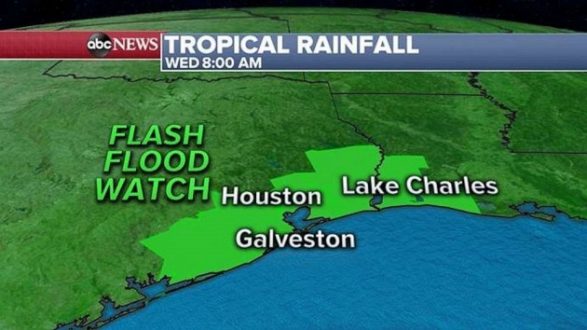
On Wednesday morning, a flash flood watch continues for Texas and Louisiana, including the areas of Houston, Galveston and Lake Charles.
This remnant low will continue moving slowly north and bring more heavy rain to Houston, then north to Lufkin and into western Louisiana. Locally, an additional 6-10” of rain is possible.
Flash flooding is the biggest threat over the next 48 hours.
Hurricane Humberto is now a major hurricane with Category 3 winds of 115 mph as it continues to move away from the United States. However high surf will continue for the entire East Coast.
The tallest waves will be in the Carolinas, where waves could be as high as 11 feet.
Humberto is forecast to pass to the north of Bermuda Wednesday evening, bringing gusty winds and heavy rain. Just in case, the National Hurricane Center issued a hurricane warning for the Bermuda for Wednesday evening.
Finally, a newly formed tropical depression in the middle of the tropical Atlantic Ocean has become Tropical Storm Jerry.
It’s forecast to move northwest just to the north of Caribbean islands as it becomes a Category 1 hurricane by Friday.
The National Hurricane Center says there is no threat to land from this storm.
Copyright © 2019, ABC Radio. All rights reserved.