


Parts of 15 counties in northern Arkansas will see low-level flights, as scientists with the U.S. Geological Survey and the Arkansas Geological Survey are partnering to image geology.
The agencies are using airborne technology as part of the USGS Earth Mapping Resource Initiative (Earth MRI) project and the National Cooperative Geologic Mapping Program.
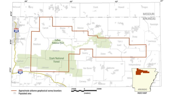
The planes and crew will be based out of the Branson Airport in Hollister, Missouri. The survey began in October and will conclude in December, weather permitting. Counties included in the survey include southern Baxter, along with parts of Marion, Izard, Searcy, Stone, Newton and Boone.
Two Piper Navajo airplanes will be mounted with passive sensors that measure variations in the Earth’s natural magnetic field. These variations are created by different rock types up to several miles beneath the surface. The magnetic sensor will be mounted on a tail stinger off the back of the aircraft.
Each plane will also include sensors inside the aircraft that measure soil and rock chemistry at the surface. None of the instruments carried on the aircraft pose a health risk to people or animals. The aircraft will be flown by experienced pilots specially trained and approved for low-level flying. All flights are coordinated with the FAA to ensure compliance in accordance with U.S. law.
The northern Arkansas survey will be flown at elevations approximately 260 to 1,000 feet above ground in a grid pattern, along north-south flight lines spaced approximately 650 feet apart. East-west flight lines will be spaced 9,800 feet apart. All survey flights will occur during daylight hours.
Data collected for this survey is part of a national-scale effort to acquire modern, high-resolution airborne magnetic and radiometric data. The survey will replace existing lower-quality geophysical data, collected mostly in the 1980s, that is of limited use for geologic mapping. The new geophysical survey will use the latest technological developments that will allow the USGS to create high-resolution 3D representations of geology to depths several miles below the surface. The 3D models and maps produced from the survey will help understand the distribution of groundwater, mineral and energy resources, as well as the potential for natural hazards. Data collected as part of the Arkansas survey will be made public and used by USGS and Arkansas Geological Survey scientists to guide more detailed geologic mapping at local scales.
Earth MRI is a cooperative effort between the USGS, the Association of American State Geologists and other federal, state and private sector organizations to improve our knowledge of the geologic framework in the U.S. The NCGMP provides accurate geologic maps to help sustain and improve the quality of life and economic vitality of the nation.
WebReadyTM Powered by WireReady® NSI