


ABC NewsBY: DANIEL MANZO, ABC NEWS
(NEW YORK) — Tropical Storm Marco is expected to become a Hurricane later today as Hurricane Warnings and Storm Surge Warnings have been issued for parts of the Gulf Coast.
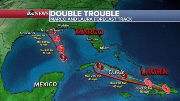
Marco is currently 395 Miles south-southeast of southern Louisiana and the storm has winds of 70 mph while moving north-northwest at 13 mph.
Laura currently is bringing torrential rain to parts of Haiti and the Dominican Republic as the storm is about 95 miles east of Port Au Prince, Haiti.
Laura has winds of 45 mph and is moving westward at 18 mph. There are Tropical Storm Watches and Warnings for parts of Hispaniola, Cuba, the Bahamas, and the Turks and Caicos Islands.
There is also a Tropical Storm Watch for the Florida Keys and the waters off southern mainland Florida.
Marco is expected to gain some strength today and then quickly move into the Gulf Coast.
As with all tropical systems, the area to the right of the center is where the greatest impacts will occur. Right now, the center of Marco looks to be coming ashore somewhere on the Gulf Coast from southern Louisiana to southern Mississippi, with the likely region being very close to New Orleans.
Marco is expected to make landfall as a Category 1 Hurricane during the day on Monday and when Marco comes ashore it will have a storm surge of 2 to 6 feet, rainfall of up to 6 inches, possible tornadoes, and strong winds.
Laura will make its way into Cuba by tonight and move across Cuba overnight into Monday.
Locally, over 8 inches of rain, strong winds and dangerous surf is expected from Hispaniola to Cuba over the next 36 hours and this will likely cause flash flooding and mudslides.
The official forecast track shows Laura possibly reaching the southern Gulf of Mexico as Marco is making landfall on Monday.
The forecast after this point remains somewhat uncertain. However, in the overnight forecast models, there is increasing agreement in a strengthening hurricane Laura moving towards the U.S. Gulf Coast later this week and this has at least some potential to be a more impactful weather event later this week on the Gulf Coast.
It remains to be seen what the intensity of both storms will be, as well as their exact location as to whether this situation would break any tropical records.
The last time there were two Tropical Cyclones in the Gulf of Mexico was in 2002, where Tropical Storm Fay was off the Texas coast and Tropical Depression Eduoard was off the Florida West Coast.
The shortest time between two landfalling named storms in Louisiana was five days and that was back in 1885.
Copyright © 2018, ABC Radio. All rights reserved.