


ABC NewsBy MAX GOLEMBO, ABC News
(NEW YORK) — Marco has weakened even more as of 5 a.m. Monday morning and winds are now down to 60 mph.
Marco is expected to continue weakening and Hurricane Warnings have been discontinued for the Louisiana coast.
Here are all the Watches and Warnings for the region this morning along with new Tropical Storm Warnings that have been issued for Laura in the Florida Keys, including Key West.
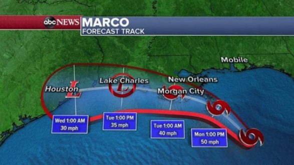
As you can see on the path map below, Marco should make landfall somewhere south of Morgan City, Louisiana, late tonight as a weak Tropical Storm.
Wind will not be an issue but a storm surge of 2 to 4 feet south of Morgan City is still expected.
Some heavy rain is also expected with, locally, more than a half a foot possible but no major flooding is anticipated.
Laura is a different creature and is just days behind Marco even though they are not connected at all.
Laura continues to strengthen this morning as it passes now south of Cuba in the warm Caribbean waters with winds now 65 mph with higher gusts.
A Tropical Storm Warning has been issued for the Florida Keys due to Laura passing to the south tonight.
Once Laura emerges over the Gulf of Mexico Monday night, environmental conditions will become favorable for possible rapid intensification and Laura could become a Category 2 hurricane on Tuesday into Wednesday with winds over 100 mph.
At this moment the landfall looks like will be in western Louisiana sometime Wednesday night between Lake Charles, Louisiana and Beaumont, Texas.
Threats with Laura will include damaging winds, deadly storm surge and flooding rain.
Copyright © 2020, ABC Audio. All rights reserved.