


ABC NewsBy MAX GOLEMBO, ABC News
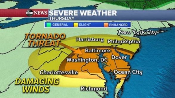
(NEW YORK) — A frontal storm system will move into the Mid-Atlantic states Thursday and will bring a threat for damaging winds and tornadoes from Washington, D.C. to Philadelphia.
Severe storms are expected to blossom in the early afternoon Thursday in western Pennsylvania and West Virginia and move east into the I-95 corridor between 5 and 6 p.m. ET.
These storms come after more than a foot of rain fell in the southern Plains. Now a flash flood threat moves into Ohio Valley for Thursday.
Rounds of heavy rain will continue to move over the same areas and that could produce flash flooding Thursday morning and into the afternoon. Locally, an additional 2 to 3 inches of rain is possible from Louisville, Kentucky, to Cincinnati and into Charleston, West Virginia.
Meanwhile, a heat dome will continue to build in the West, pushing temperatures into the 100s.
Numerous heat warnings, watches and advisories have been issued for Oregon, California, Nevada, Arizona and Utah.
Some cities could even see near-record highs Thursday, including Medford, Oregon and Portland, Oregon.
Copyright © 2020, ABC Audio. All rights reserved.