


 ABC NewsBy MAX GOLEMBO and WILLIAM MANSELL, ABC News
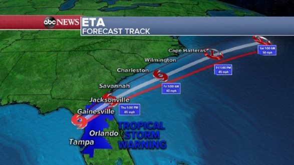
(NEW YORK) — Eta made landfall early Thursday morning as a tropical storm near Cedar Key, Florida, according to the National Hurricane Center in Miami.
The storm hit with maximum sustained winds of 50 mph. It is producing heavy rains and gusty winds for portions of the Florida Gulf Coast and northern Florida peninsula. Eta is moving toward the northeast near 13 mph.
As of 4 a.m., the tropical storm warning south of Longboat Key and the tropical storm watch has been discontinued. However, a storm surge warning is in effect for the Middle of Longboat Key to the Suwannee River, including Tampa Bay.
Tampa Bay saw 3.87 feet of storm surge Thursday, which is the highest storm surge in the area since 1991.
The highest wind gust from Eta Thursday was 69 mph in Port Charlotte, Florida, which is located between Fort Myers and Sarasota.
A tropical storm warning, according to the NHC, is in effect for the middle of Longboat Key to the Suwannee River and from the Flagler/Volusia County Florida line north to St. Andrews Sound in Georgia.
Flood watches continue Thursday morning, from Florida all the way up the coast to Maryland.
Eta is expected to emerge into the western Atlantic Thursday afternoon. The storm is forecast to accelerate over the western Atlantic and move parallel to, but offshore, of the Carolinas before heading well east into the Atlantic Friday, the NHC said.
Eta will produce an additional 1 to 3 inches of rain across parts of Florida Thursday, with isolated maximum storm total accumulations of 20 to 25 inches in south Florida.
Some of the highest rainfall totals overnight are up to a half a foot of rain from Florida to North Carolina.
The heaviest Thursday will be in the Carolinas and parts of the southern Mid-Atlantic, where half a foot is possible in areas, which could cause flash flooding.
After Eta, the tropical systems are still not done. There is a new tropical wave moving through the Caribbean, and could become the next Greek-named storm, Iota. It could bring flooding rain this weekend into next week for hard-hit Central America.
Copyright © 2020, ABC Audio. All rights reserved.