


To ensure public safety, a large portion of the Lower Buffalo Wilderness in Marion County will be closed to horse and foot traffic between Feb. 22 and March 23, while the National Park Service conducts a prescribed burn within Buffalo National River. The river corridor will remain open, with canoes and john boats allowed, and camping permitted on gravel bars.
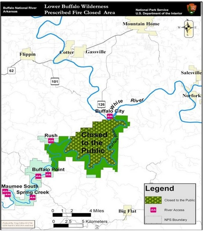
The prescribed burn will take place on approximately 11,284 acres of public land within the Lower Buffalo Wilderness Prescribed Fire Unit, located in southeast Marion County, about seven miles southeast of Flippin. Actual ignition dates will depend on favorable weather conditions. The burn is expected to take eight to 12 days to complete and may require multiple burn periods to take advantage of suitable weather. The closure will be lifted as soon as the burn is complete and the area is determined to be safe.
The purpose of the prescribed burn is to restore and maintain fire as a natural ecological process, reduce the buildup of dead and downed fuels, lower the risk of future catastrophic wildfire and provide wildfire protection for adjacent lands.
The closure area includes lands north of the Buffalo River, bounded on the north by the park boundary between Cedar Creek and the White River, and on the south by the Buffalo River.
WebReadyTM Powered by WireReady® NSI