


For the remainder of the month a controlled burn is planned on public lands administered by the National Park Service inside the Lower Buffalo Wilderness, Buffalo National River. The actual dates will be determined based on weather conditions.
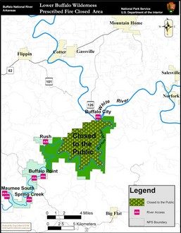
The 11,284-acre Lower Buffalo Wilderness Prescribed Fire Unit is located in southeast Marion County, approximately 7 miles southeast of Flippin. It is anticipated the entire unit will take eight to 12 days to burn from start to finish. It is expected several periods of predetermined favorable weather conditions may be necessary to complete the burn.To ensure public safety during this time all horse and foot traffic will be prohibited in the Lower Buffalo Wilderness, but the river will be open to boat traffic and camping will be allowed on gravel bars. As soon as the burn is complete and the area is considered safe the closure will be lifted.
The purpose for conducting the prescribed burn is to promote the restoration and maintenance of fire as a natural component of ecosystem processes. The prescribed burn will reduce the accumulation of dead and down fuels lowering the chances for a catastrophic wildfire in the future and to provide wildfire protection for adjacent lands.
The area of the closure is on the north side of the Buffalo River, bounded on the north by the park boundary between Cedar Creek and the White River and on the south by the Buffalo River.
WebReadyTM Powered by WireReady® NSI