


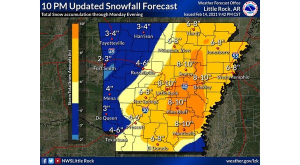
The Twin Lakes Area has seen a significant amount of snow beginning Sunday and continuing through Monday morning. At KTLO, Classic Hits and The Boot, the official reporting stations for the National Weather Service for Mountain Home, 3 inches of snow have fallen, and according to Meteorologist Chuck Rickard, more is expected.
Listen:
The area also has a record low for the second consecutive day. As of 6 a.m., the temperature was 1 degree. The previous record was 10 set back in 1944.
The entire area is under a winter storm warning until 6 p.m. Monday and a wind chill warning until 9 a.m. Tuesday. Lows could get below zero Tuesday morning.
Rickard says another round of snow is expected Wednesday and Thursday.
Listen:
The last time the temperature was at or below zero at KTLO, Classic Hits and The Boot was when it hit -1 on Jan. 17, 2018. We last had over 4 inches of snow March 12, 2017, over 6 inches on March 5, 2015, and over 8 inches on Feb. 10, 2011.
For closings, cancellations and information on road conditions, go to the Baxter Regional Medical Center cancellation page at ktlo.com/cancellations.
WebReadyTM Powered by WireReady® NSI