


Severe weather chances originally forecasted for Friday evening over the Twin Lakes area has been diminished in the latest briefing from the National Weather Service with the focus now landing on Saturday and Sunday.
A Flood Watch is in effect for the north central portion of the Natural State through Sunday, with forecasters warning of several rounds of heavy rain and strong to severe thunderstorms.
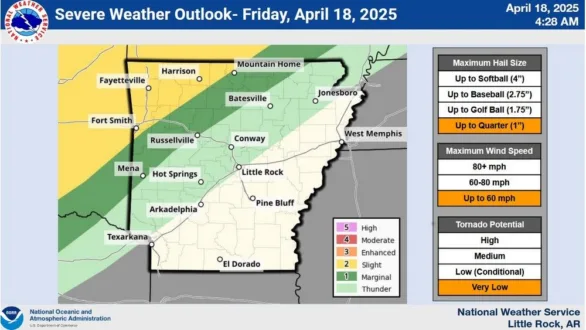
The most immediate threat on Friday is focused on far northwest Arkansas, where storms could bring damaging winds, large hail, and isolated flooding. However, the risk is expected to expand Saturday into Sunday, with severe weather possible across a wider portion of northern Arkansas, including the north central region.
The weather service says moderate to at times heavy rain is expected from Friday afternoon through early Monday. In the most likely scenario, 1 to 2 inches of rain could fall across north central Arkansas. A worst case forecast shows totals as high as 4 inches in some areas.
By Sunday, the tornado threat is expected to increase, particularly in areas near a warm front lifting through northern Arkansas. Damaging winds, large hail, and isolated tornadoes are possible.
Any exessive rainfal could bring a threat for flash flooding as low lying areas remain saturated from previous rounds of heavy rain.
WebReadyTM Powered by WireReady® NSI