


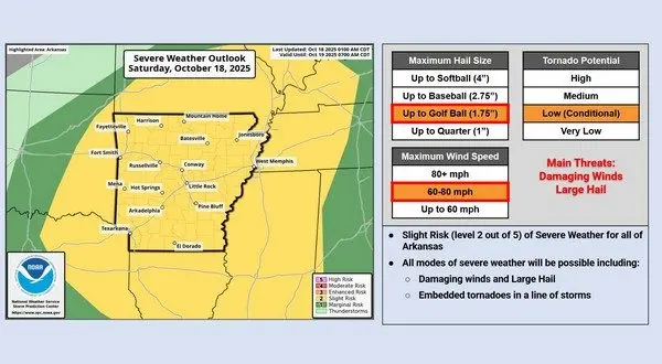
The National Weather Service (NWS) has issued a briefing on Saturday warning of severe weather entering the area with threat of damaging winds, large hail, flash flooding and the potential for tornadoes. KTLO, Classic Hits and the Boot News reached out to NWS Meteorologist Jimmy Barham to get a breakdown on what local residents can expect as this line of storms enters the Twin Lakes area.
Barham says that the line will push into the Fayetteville area around noon and will push through the Twin Lakes around 2-4.
Listen:
As this line moves through the area, Barham says conditions will be hazardous and urges listeners to avoid traveling in that time frame.
Listen:
Barham says the greatest threat will be strong winds, with the risk of large hail decreasing as the line of storms moves into the listening area. The risk for tornadic activity appears to be isolated with the potential for weaker embedded tornadoes on the edge of the storm.
Listen:
As always, you can keep your radios tuned to KTLO, Classic Hits and the Boot or visit ktlo.com to stay up-to-date on weather conditions as they develop.
WebReadyTM Powered by WireReady® NSI