


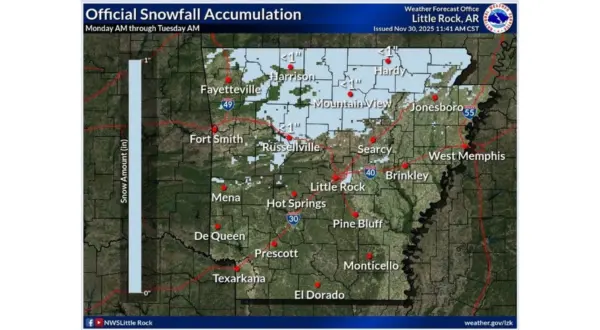
The Twin Lakes area looks to face its first taste of winter weather Monday with impacts to travel possible in the afternoon.The National Weather Service (NWS) has issued a Winter Weather Advisory for Baxter, Fulton, Izard, Stone and Sharp counties in Arkansas until 6 Tuesday morning. According to the NWS mixed precipitation is expected across the area starting around noon until the evening hours. A light band of snow could pass over the area after dark with most winter weather chances diminishing by midnight. Total snow and sleet accumulations could be up to a few tenths of an inch, primarily across northern to central Arkansas. Ice accumulations from a light glazing up to one tenth of an inch are also possible. Cold arctic air will contribute to any freezing that will occur with temperatures remaining below freezing and wind chills in the teens throughout the day.
All of these conditions conditions could impact travel Monday according to NWS meteorologist Joe Goudsward.
Listen:
It will be important when traveling to slow down and use caution. The latest road conditions across Arkansas can be found at www.idrivearkansas.com
Road Conditions for Missouri are available at www.modot.org.
To submit a closing or cancellation to KTLO, Classic Hits and The Boot News send an email to news@ktlo.com or call (870) 425-3101.
For a list of up-to-date closings and cancellations, visit www.ktlo.com/cancellations-business/#!/
Warmer weather is expected Tuesday with temperatures returning to near 50 degrees by Wednesday.
WebReadyTM Powered by WireReady® NSI