


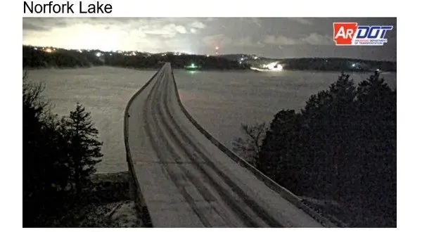
ARDOT camera shows HWY 62 at Henderson Bridge at 6am Saturday
Snow is beginning to accumulate and impact travel in the Twin Lakes area early Saturday as the National Weather Service (NWS) predicts more heavy snow into Sunday and an extended freeze warning now into Monday.
As of 6am on Saturday 3/4 of an inch of snow had fallen at KTLO, Classic Hits and The Boot studios in Mountain Home. NWS meteorologist Alex Young tells KTLO News that another 2-5 inches of snow is coming through mid day.
Listen:
A second wave will begin later Saturday evening and continue into Sunday morning with heavy snow and sleet with another 3-8 inches of snow possible.
Listen:
When the snow ends Sunday afternoon the area will be grappling with extreme cold temperatures. Young says the NWS has extended the Extreme Cold Warning through Monday.
Listen:
Stay tuned to KTLO, Classic Hits and the Boot for the latest in closings, road conditions and updated weather forecasts.
Road conditions by IDrive Arkansas
WebReadyTM Powered by WireReady® NSI