


A line of storms Sunday afternoon will bring a shocking drop in temperatures and even light snow as winter makes one more appearance before spring arrives in five days.
A report from the National Weather Service (NWS) in North Little Rock Sunday morning shows the previously forecasted enhanced risk of severe weather storms has been downgraded to a slight risk for North Central Arkansas. Stronger storms are forecasted to develop east towards the Arkansas Tennessee state line.
The risk for severe weather still remains and locals should stay aware through the day as the chance for strong winds, golf ball sized hail and tornadoes still remains in play. Timing will begin in the early after with the storms pushing east by 5 p.m. The NWS has issued a Wind Advisory through Monday morning with sustained winds of 15- 30 mph and gust over 50 mph. Straight line winds could damage trees and utilities leading to power disruptions. Care should be taken to secure property heading into the storm.
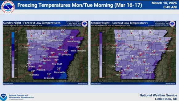
A Freeze Warning has been issued for the area after midnight into Monday morning. Following the storms Sunday afternoon frigid cold air will move into the area and lows could drop down to the teens with wind chills in the single digits. Near record cold temperatures will continue into Monday with highs only expected in the low 30s and Monday night dropping into the teens again.
Sensitive vegetation, animals, and utilities should be monitored during the extreme cold. By Tuesday temperatures return to near average highs around 50 degrees with near 85 degrees forecasted for the following weekend.
Stay tuned to KTLO, Classic Hits and The Boot for live severe weather coverage Sunday afternoon.
WebReadyTM Powered by WireReady® NSI