


An active weather pattern is expected across the region through the weekend and into early next week, according to National Weather Services meteorologist Eric Green.Green says scattered thunderstorm activity is possible late Saturday night, with some storms potentially moving in from western Arkansas.
Listen:
Listen:
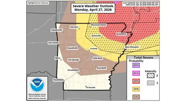
The greatest concern turns to Monday, when the region, including northern Arkansas and southern Missouri, could see a higher potential for severe weather. Green says some uncertainty remains regarding exact timing and location.
A stalled front over the Ozark Plateau is contributing to the unsettled conditions. The boundary is also causing shifting wind directions and some locations remaining cooler under cloud cover while others warm significantly just a few miles away.
Listen:
Green encourages residents to prepare now by reviewing or creating a severe weather safety plan ahead of Monday’s potential storms.
WebReadyTM Powered by WireReady® NSI