


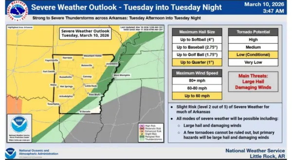
Tuesday night into early Wednesday is showing the chance of severe weather with hail strong winds leading as top threats.According to a release from the National Weather Service (NWS) most of the state is under a slight or 2 out of 5 risk level for severe weather. Strong storms are projected to impact northwestern Arkansas before moving east towards the Twin Lakes area. Radar projections show light chances of rain and thunderstorms in the evening through midnight. Storm chances increase after midnight primarily from around 3am to 6am Wednesday.
The tornado potential remains low with high winds and quarter sized hail possible through early Wednesday morning. Expected rainfall is upwards of half an inch.
Wednesday shows storm chances shifting south for the area with cooler air moving into the area bring temperatures closer to average highs through the rest of the week. A major drop in temperatures is possible by early next week with a freeze possible.
Stay tuned to KTLO, Classic Hits and The Boot for the latest in severe weather updates.
WebReadyTM Powered by WireReady® NSI