


 ABC News(NEW YORK) — The storm that plagued the Northeast on Friday is still working its way up the New England coast on Saturday morning.
Rain showers stretch from Virginia to Maine, while snow is falling in the higher elevations of West Virginia, Pennsylvania and New York. While there are a few spots of moderate rainfall, most of the showers Saturday morning are light and should not contribute much to accumulation totals.
More than 2 inches of rain fell across much of the region on Friday, including 2.01 inches at JFK Airport in New York City; 2.66 inches in Westwood, New Jersey; and 3.28 inches in Woodbridge, Connecticut.
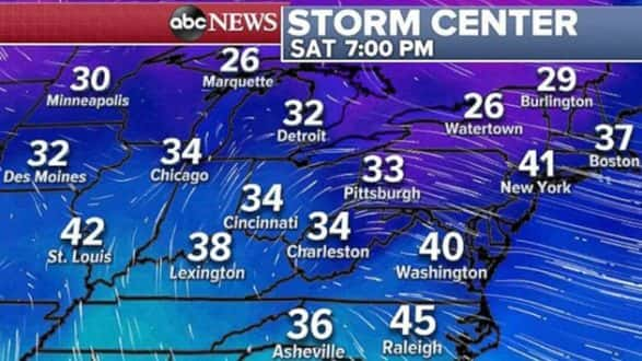
Behind the rain showers is colder air that is pushing its way into the area. Temperatures will fall throughout the day on Saturday and return to more seasonable values for this time of year — 30s and 40s — by evening.
By Sunday morning, wind chill values will range from the teens to 20s for much of the Ohio River Valley and the Northeast.
Round of western storms
Numerous low-pressure systems have developed in the northern Pacific Ocean and will trek eastward. This means that unsettled weather is in store for the Pacific Northwest.
The first system will arrive onshore late Saturday afternoon, bringing rain from Washington to Northern California. Higher elevations in this region can expect snow.
Such conditions are going to make travel in the Northwest tricky this weekend. With the upcoming holiday and increased traffic, drivers should be extra careful and plan for slow travel and possible impassable roads.
The system will linger in the area through Sunday afternoon, only to be followed by another low — and more rain — Sunday night into Monday.
Copyright © 2018, ABC Radio. All rights reserved.