


Another round of winter weather could start affecting the Twin Lakes Area by Wednesday morning. A winter weather advisory has been issued for portions of North Central Arkansas from 6 Wednesday morning through 6 Thursday morning. A winter weather advisory means periods of snow, sleet or freezing rain will cause travel difficulties.
Heather Cross with the National Weather Service says the winter storm will be a widespread event and sets the timetable for the weather.
Listen:
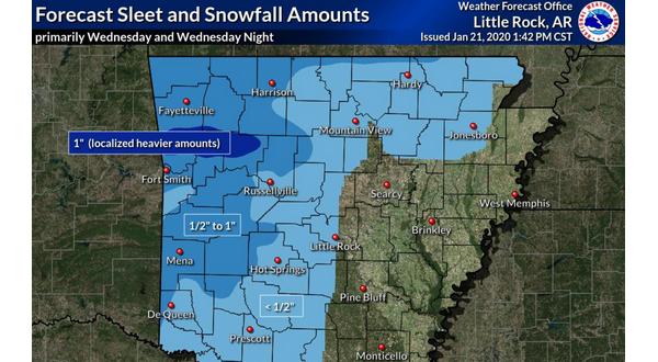
The winter weather advisory is for roughly the northwest one-third of Arkansas including Baxter, Marion, Boone, Searcy and Newton counties.
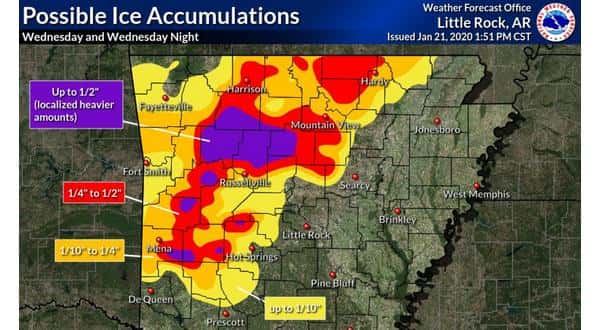
Cross adds accumulation could vary across the state, with locally heavy amounts possible.
Listen:
You can stay up-to-date on cancellations and road conditions in Arkansas and Missouri at ktlo.com/cancellations brought to you by Baxter Regional Medical Center.
* ACCUMULATIONS…Minor accumulation of snow and sleet up to inch
inch will be possible in some areas. Up to one quarter of an
inch of ice is possible as precipitation transitions to freezing
rain.
* ADDITIONAL DETAILS…Cold surface temperatures will allow the
snow/sleet and freezing rain to cause some slick spots on area
roadways, especially elevated surfaces such as bridges and
overpasses. Some areas will warm above freezing during the day
Wednesday, while other locations will remain at or below
freezing. Areas that remain at or below freezing will likely see
the highest ice accruals.
WebReadyTM Powered by WireReady® NSI