


Despite a new daily rainfall record being set because of the heavy rain Monday and Monday night, there are no reports of flooding problems in the area. The National Weather Service says more rain this week could cause flooding and a greater chance of severe storms is forecast for Thursday.
While flash flood warnings were issued for many areas of north central Arkansas, there are no reports of damage. A check with sheriff’s offices in the area indicates no road flooding has been reported and all area roads are open.
A total of 2.78 inches of rain was recorded at the KTLO, Classic Hits and The Boot Studios, the official reporting station in Mountain Home for the National Weather Service, which is a new daily rainfall record for the date. The old record of 2.28 inches was set in 1990.
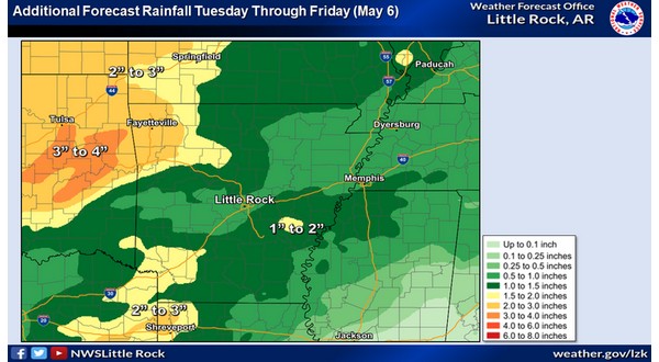
While no flooding is being reported at this time, the potential exists later this week. Meteorologist Willie Gilmore with the National Weather Service in North Little Rock says more rain is on the way.
Listen:
Gilmore says we will have to pay attention to the weather Thursday when more severe weather is possible.
Listen:
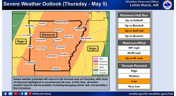
The Storm Prediction Center has placed most of Arkansas, including all of the Twin Lakes Area, in the enhanced category for severe weather on Thursday. An enhanced risk for severe weather means numerous severe storms are possible and are more persistent and widespread with a few instances of very intense storms. Under this risk, several spots will likely experience damaging winds and/or large hail.
WebReadyTM Powered by WireReady® NSI