


As thunderstorms and heavy rains make their way out of the Twin Lakes Area Monday morning the focus is now turning to the next round of severe weather currently predicted to impact the area Wednesday evening.
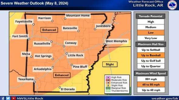
According to a release from the National Weather Service (NWS), chances for severe weather will increase Wednesday as a storm system tracks from the southern Plains to the mid-Mississippi Valley, and drags a cold front into Arkansas. Ahead of the front, well above average temperatures and humid conditions will create a very
unstable environment.
All modes of severe weather are in play. Very large hail up to baseball size and wind gusts up to 80 mph are the main threats, with tornadoes also possible. Heavy downpours may lead to localized flash flooding as well.
NWS Meteorologist Willie Gilmore shares the following Monday morning weather update.
Listen:
Clear and cooler conditions are predicted the rest of the week. Stay tuned to KTLO, Classic Hits and The Boot for up to date severe weather coverage.
WebReadyTM Powered by WireReady® NSI