


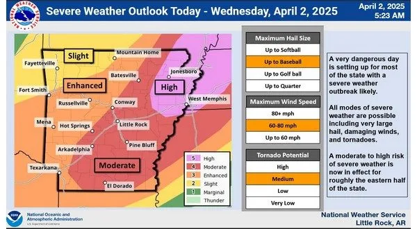
Residents should prepare for a dangerous stretch of severe weather beginning Wednesday afternoon, according to the National Weather Service (NWS). The Twin Lakes region and much of Arkansas are at risk for damaging storms, heavy rainfall, and life-threatening flooding through Saturday night.Severe thunderstorms are expected to develop by noon Wednesday, bringing the potential for very large hail, damaging wind gusts, and tornadoes. The storms will continue into the night, impacting the entire state. Additional rounds of severe weather are likely on Thursday, Friday, and Saturday, with each day carrying a risk of damaging conditions in most of Arkansas, except for far northwest portions of the state.
The NWS has introduced a high risk of severe weather for Wednesday and Wednesday night, with very large hail, damaging winds, and strong tornadoes expected in the most at-risk areas. While some parts of the state may experience significant storm damage, the heavy rainfall threat is equallyif not moresevere. Rainfall amounts in the forecast are rarely seen in Arkansas, with some areas expected to receive more than 10 inches. The NWS notes that some parts of the state have not seen such high totals in nearly 50 to 100 years.
If these rainfall predictions hold, catastrophic flash flooding and major river flooding are likely. The NWS warns that rising water levels could create life-threatening conditions. Residents in low-lying areas or near rivers should be especially cautious and prepare for possible evacuations.
The most intense weather is expected Wednesday afternoon through the night, with further severe weather threats persisting through the end of the week.
Officials recommend securing outdoor items, having a weather radio or alert system on hand, and making plans for shelter in case of tornado warnings. Motorists should avoid driving through flooded roads, as water levels can be deceptive and dangerous.
Stay tuned to KTLO, Classic Hits and the Boot for the latest in severe weather coverage.
WebReadyTM Powered by WireReady® NSI