


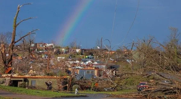
Arkansas has become more prone to tornadoes and hail storms as climate change and other weather phenomenon shift storms farther east and south, experts say. Here, a rainbow appears after a March 31, 2023, tornado tore a path through Little Rock. (Photo by John Sykes/Arkansas Advocate)
In the 30 days after several damaging twisters hit Arkansas on March 14, the state saw nearly four times as many tornado warnings as Texas did.
The National Weather Service issued 144 warnings in Arkansas, compared to 39 in Texas from March 14 to April 14. Mississippi also recorded 144 warnings over the same period and Tennessee saw 125 warnings. Alabama noted 57 warnings.
It’s an indication that the classic “Tornado Alley” region – the area from central Texas through Oklahoma and Kansas, so named because of the number of tornadoes there – is shifting eastward.
The shift is attributed to climate change, the warming of the Gulf of Mexico’s waters and a dip in the cold jet stream pattern.
Arkansas, scientists say, is nearly in the bull’s eye of a new tornado-prone area that’s referred to as “Dixie Alley.” The region, which has seen a vast increase in tornadoes over the past several years, also encompasses Mississippi, Alabama and western Tennessee.
Weather Service survey teams have already confirmed 35 tornadoes have touched down in Arkansas through April. The state averages 42 twisters per year.
The storms have also been larger. Arkansas was hit with two EF-4 twisters on March 14 – one in Jackson County and one in Izard County.
The last time a tornado of that strength hit the state was on April 27, 2014, when a tornado cut a 41-mile path of destruction through western Pulaski County, Mayflower and Vilonia in Faulkner County, and on into White County. Sixteen people died in that storm.
Victor Gensini, a professor of meteorology at Northern Illinois University in DeKalb, Illinois, conducted research about the shift, authoring a paper in 2018 that noted the change. Since then, he’s continued to monitor the trend and says the trend is ongoing.
“It’s still more prevalent in the southeast,” he said. “And we’re seeing more evidence of that each year.”
‘Drying up’
Gensini tracked tornado reports from 1979 to 2018 for his initial study, but also noted atmospheric conditions in the areas at the time that were favorable for the formation of tornadoes.
Gensini blames a combination of weather phenomenon for the increase in Arkansas’ tornadoes. A drought in the southwest is taking away needed moisture for the formation of twisters in the traditional Tornado Alley region.
More than 67% of Arizona is experiencing “extreme” and “exceptional” drought conditions – the two highest levels of drought, according to the U.S. Drought Monitor. The Drought Monitor is based at the University of Nebraska in Lincoln and records weather conditions and patterns weekly.
Three months ago, only 17% of Arizona was under the same two drought conditions. A year ago, the state was considered free from extreme and exceptional drought.
New Mexico, Texas and Utah have also seen increases in drought in their respective states. Thirty percent of Texas is in “extreme” and “exceptional” drought, an increase from 14% three months ago.
“The most intense levels of drought now cover a broad area from southeastern California, southern Nevada, and southwestern Utah through much of Arizona, New Mexico and the Texas Big Bend, said Richard Tinker, a meteorologist with the Climate Prediction Center in College Park, Maryland, and the author of the latest drought report.
“The southern Great Plains are drying up,” Gensini added.
Faster rate of change
The dry atmospheric conditions in the southwest create a dome of high pressure over the western U.S., sapping energy from the atmosphere and forcing potential tornado-producing systems to move further east. The jet stream, a strong current of frigid Arctic air, is also dipping further south into the Mississippi delta region because of the Southwestern drought.
Water temperature in the Gulf has also increased on average by one or two degrees, creating the moist, humid air needed for tornadoes.
“One or two degrees may not seem much. But think of the difference between 32 degrees and 33 degrees,” Gensini said, referring to the temperature when water freezes. “It’s early in the season, and the waters are warmer. That warm, humid air is heading into Arkansas where the air has been unstable already. It makes things more potent.
“We’re seeing weather pattern changes over the last 70 to 80 years that didn’t happen in 100,000 to 120,000 years before,” he said. “There is such a rapid rate of change, and it’s not lessening.”
Of the 144 warnings issued in Arkansas between March 14 and April 14, not all produced tornadoes, said Dennis Cavanaugh, the National Weather Service warning coordinator in North Little Rock.
In fact, the Weather Service strives to keep its “false alarm” rate of tornado warnings to less than 80%. Warnings are issued when Doppler weather radar picks up rotation in clouds, signature “inflow notches” that indicate the building of cyclonic air patterns, hail cores and other indicators.
The Weather Service also must balance the need to warn people while also not unnecessarily alarming them. Issue too many warnings that don’t produce tornadoes, and the public may become complacent and not heed future warnings as seriously. John Robinson, a former Meteorologist in Charge at the North Little Rock station, used to say that more people were injured in tornadoes while gawking at clouds for confirmation of those tornadoes rather than seeking shelter when warnings were issued.
On the other side, if the Weather Service curtails its warnings and an unwarned tornado does form, results could be devastating.
“Radar can’t see tornadoes,” Cavanaugh said. “It can see circulation aloft when it’s likely a tornado is forming. If we wait to see the debris cloud from a tornado that’s on the ground to issue a warning, it’s much too late.”
More hail
Cavanaugh said continued advances in technology should help the Weather Service lower its rate of false alarms. But the service will always rely on trained storm spotters who can see the lowering of wall clouds – a first step in the formation of tornadoes – and any circulation of clouds overhead.
“That’s really not applicable to this year,” he said of the fear that the scores of warnings issued may eventually be ignored. “I don’t think the average Arkansan thought he or she was not warned unnecessarily.”
During a round of storms one April evening, Ryan Vaughn, the meteorologist for KAIT8 in Jonesboro, was broadcasting live storm coverage. At one point, most of northeast Arkansas was placed under a myriad of tornado warnings.
Vaughn took a deep sigh on air.
“I don’t think I’ve ever said this before, but if you’re anywhere in northeast Arkansas, take cover now,” he told viewers.
Tornadoes are formed by opposing winds at various levels. Strong winds in opposite directions cause a shear and a horizontal column of air circulating overhead. Warm, humid air feeds the twister and eventually the column of air begins tilting vertically and lowering to become a destructive tornado.
And if the increase in tornadoes in Arkansas and the Delta is not enough, Gensini said the ingredients for twister formation should also cause larger hail storms.
Hail is formed inside supercell thunderstorms. The rising air inside a building storm lofts raindrops into freezing air. It causes hail, which falls to the ground. Many times, a frozen raindrop falls in the size of a pea or gravel. But with more convection inside the stronger storms, that pea-sized bit of hail is lofted over and over again inside the system, growing larger as more water freezes on it.
That’s what causes the golf ball- and baseball-sized hail and are indicative of stronger storms and tornadoes.
Gensini is about to embark on a 40-day field study this summer of hail storms.
“Tornadoes get all the attention on the news because of the visual destruction,” he said. “You see a path of destruction with shattered homes. But hail is much worse overall. It damages roofs, cars and agriculture in a much larger area.
“I think the south and southeast will see a lot more problems in the years coming,” he said.
To view this story, or for more news updates from Arkansas Advocate, click here.
WebReadyTM Powered by WireReady® NSI