


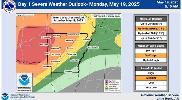
The National Weather Service is warning residents across North Central Arkansas to prepare for the possibility of severe storms and heavy rainfall beginning late Monday afternoon and continuing into Tuesday morning.
A line of strong thunderstorms is expected to move into Arkansas from Oklahoma between 4 and 6 p.m. Monday, continuing eastward through the evening and overnight hours. While a few isolated storms could develop earlier in the afternoon across central and northern Arkansas, the main threat comes from a larger complex of storms expected later in the day.
Forecasters say these storms could bring damaging winds, hail, and heavy rainfall. A Flood Watch is in effect for much of northern Arkansas starting Monday afternoon and continuing through Tuesday morning, with rainfall totals of 2 to 4 inches possible. Some areas could see even higher amounts, increasing the risk of flash flooding.
While the storms are expected to gradually weaken as they move into eastern Arkansas early Tuesday morning, they may still maintain strong to severe characteristics.
Conditions are forecast to improve after Tuesday, with calmer weather expected for at least the rest of the week.
Stay tuned to KTLO, Classic Hits and the Boot on air and online for the latest in weather coverage.
WebReadyTM Powered by WireReady® NSI